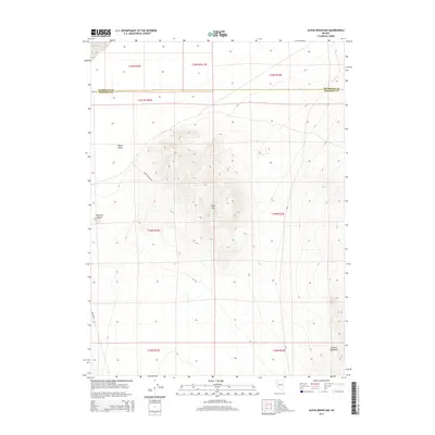
2014 Map of Alpha Mountain
USGS Topo · Published 2014About this map
Alpha Mtn dominates this high-desert landscape in northern Nevada, rising from the floor of Desert Valley near the border of Humboldt and Pershing Counties. This 2014 survey captures a remote region defined by dramatic topographic shifts, from the open basin in the west to the southern reaches of the Eugene Mountains in the southeast corner. Human imprint is sparse, represented primarily by unpaved travel corridors that trace the natural contours of the land. Woody Canyon Rd winds across the western slopes of the mountain, while Jungo Rd skirts the southwestern corner, providing access to this interior wilderness. The map is a study in Great Basin land management, clearly delineating the complex system of township and range lines, such as t34n r32e, that impose a geometric order on the varied terrain around Haystack Butte.
Find a feature on this map
15 named features on this map. Tap any name to fly to it.
Don’t see what you’re looking for? This feature index may not catch every label — zoom into the map to look around manually.
Map Details
Editions of this 2014 Alpha Mountain Map
This is the sole edition of this map. No revisions or reprints were ever made.
Other maps of this area

1931 · Lovelock
USGS Topo · 1:250,000

1935 · Lovelock
USGS Topo · 1:250,000

1939 · Eugene Mountains Area
USGS Topo · 1:62,500

1942 · Eugene Mountains Area
USGS Topo · 1:62,500

1955 · Lovelock
USGS Topo · 1:250,000

1956 · Imlay
USGS Topo · 1:62,500

1959 · Lovelock
USGS Topo · 1:250,000

1971 · Majuba Mtn
USGS Topo · 1:24,000

1971 · Rye Patch Reservoir North
USGS Topo · 1:24,000
1971 · Jungo
USGS Topo · 1:24,000