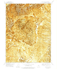
1971 Map of Alpha Mountain
USGS Topo · Published 1977About this map
Alpha Mountain dominates this 1970s orthophoto survey, providing a detailed photographic record of the high desert terrain along the Humboldt Co Pershing Co boundary. The map captures a landscape defined by aridity and isolation, where transportation is limited to a network of a Jeep Trail winding through the alluvial fans and volcanic formations. Evidence of human activity is sparse but significant, centered on resource extraction and livestock management. Several Prospects are marked on the northern slopes, reflecting the region's mineral potential, while a lone Corral in the southeast suggests the seasonal movement of cattle through this arid range. To the northwest, the white expanse of Alkali Flats indicates a dry lake bed, while the prominent landmark of Haystack Butte rises sharply from the surrounding flats.
Find a feature on this map
8 named features on this map. Tap any name to fly to it.
Don’t see what you’re looking for? This feature index may not catch every label — zoom into the map to look around manually.
Map Details
Editions of this 1971 Alpha Mountain Map
This is the sole edition of this map. No revisions or reprints were ever made.
Other maps of this area

1931 · Lovelock
USGS Topo · 1:250,000

1935 · Lovelock
USGS Topo · 1:250,000

1939 · Eugene Mountains Area
USGS Topo · 1:62,500

1942 · Eugene Mountains Area
USGS Topo · 1:62,500

1955 · Lovelock
USGS Topo · 1:250,000

1956 · Imlay
USGS Topo · 1:62,500

1959 · Lovelock
USGS Topo · 1:250,000

1971 · Majuba Mtn
USGS Topo · 1:24,000

1971 · Rye Patch Reservoir North
USGS Topo · 1:24,000
1971 · Jungo
USGS Topo · 1:24,000