Loading...
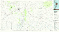
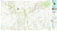
Loading map...1985 Map of Alpine
USGS Topo · Published 1985About this map
Alpine serves as the primary hub of this West Texas landscape during the mid-1980s, where the Southern Pacific and Atchison Topeka and Santa Fe railroads converge. The map documents a vast network of mesas, mountains, and draws typical of the Trans-Pecos region, stretching from the Glass Mountains in the northeast to Elephant Mountain in the south. The distribution of small settlements like Marathon, Altuda, and Haymond along the rail lines illustrates the enduring importance of transit corridors through the high desert terrain.
Find a feature on this map
75 named features on this map. Tap any name to fly to it.
Don’t see what you’re looking for? This feature index may not catch every label — zoom into the map to look around manually.
Map Details
Date Portrayed1985
Date Published1985
PublisherU.S. Geological Survey
Map TypeTopographic
Scale1:100,000
Physical Dimensions43.9 x 24.1 inches
Editions of this 1985 Alpine Map
2 editions found
Historical Maps of Alpine Through Time
Featured Locations
Source Details
SourceU.S. Geological Survey
CopyrightPublic Domain