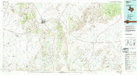
1985 Map of Alpine
USGS Topo · Published 1994About this map
Alpine serves as the primary hub of this High Desert landscape in the mid-1980s, anchored by the campus of Sul Ross State Univ and its proximity to the Southern Pacific railroad line. The map captures a region defined by massive volcanic and limestone formations, from the sprawling Glass Mountains in the northeast to the prominent profile of Mitre Peak. To the east, the small community of Marathon marks a vital junction where 90 and 385 intersect, while the tracks of the Southern Pacific pass through remote sidings at Warwick and Haymond.
Find a feature on this map
102 named features on this map. Tap any name to fly to it.
Don’t see what you’re looking for? This feature index may not catch every label — zoom into the map to look around manually.
Map Details
Editions of this 1985 Alpine Map
2 editions found
Other maps of this area

1894 · Valentine
USGS Topo · 1:125,000

1894 · Fort Davis
USGS Topo · 1:125,000

1895 · Marfa
USGS Topo · 1:125,000

1895 · Alpine
USGS Topo · 1:125,000

1896 · Shafter
USGS Topo · 1:125,000

1897 · Valentine
USGS Topo · 1:125,000

1897 · Fort Davis
USGS Topo · 1:125,000

1917 · Santiago Peak
USGS Topo · 1:62,500

1917 · Buck Hill
USGS Topo · 1:62,500

1917 · Hood Spring
USGS Topo · 1:62,500