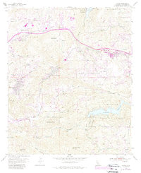
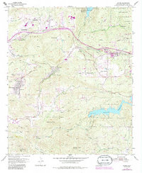
1955 Map of Alpine
USGS Topo · Published 1988About this map
Alpine and the surrounding San Diego County backcountry are documented here following a mid-century field check, capturing a landscape defined by rugged canyons and increasing residential development. The terrain is marked by significant elevation changes from Sycuan Peak and McGinty Mtn down to the basins of the Loveland Reservoir and El Capitan Reservoir. The map reveals a distinct pattern of small ranches and named settlements, such as Harbison Canyon, La Cresta, and Suncrest, many of which developed along canyon floors and ridgelines.
Find a feature on this map
49 named features on this map. Tap any name to fly to it.
Don’t see what you’re looking for? This feature index may not catch every label — zoom into the map to look around manually.
Map Details
Editions of this 1955 Alpine Map
5 editions found
Other maps of this area

1893 · El Cajon
USGS Topo · 1:62,500

1901 · Elcajon
USGS Topo · 1:62,500

1903 · Cuyamaca
USGS Topo · 1:125,000

1903 · Elcajon
USGS Topo · 1:62,500

1904 · Southern California Sheet No. 2
USGS Topo · 1:250,000

1939 · El Cajon
USGS Topo · 1:62,500

1942 · Potrero
USGS Topo · 1:48,000

1942 · El Cajon
USGS Topo · 1:62,500

1942 · Cuyamaca Peak
USGS Topo · 1:62,500

1943 · Jamul
USGS Topo · 1:62,500