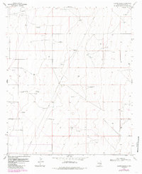
1970 Map of Alston Ranch
USGS Topo · Published 1986About this map
The Ranger Lake Oil Field anchors the northwest corner of this Lea County landscape, illustrating the critical intersection of energy extraction and ranching in the High Plains. While industrial features like a Gravel Pit and numerous Drill Hole locations mark the ground, the map is defined by a sparse but vital network of water infrastructure. Named windmills, including Goat Windmill, Sartin Windmill, and the curiously titled Old Man Windmill, serve as the primary landmarks across the terrain. These scattered stations, along with the Old Dipping Vat Windmill, point to the enduring livestock operations at the Alston Ranch and Peveler Place during the early 1970s. The distribution of these features reveals how water management dictated the spatial organization of this arid territory before late-century shifts in land use.
Find a feature on this map
14 named features on this map. Tap any name to fly to it.
Don’t see what you’re looking for? This feature index may not catch every label — zoom into the map to look around manually.
Map Details
Editions of this 1970 Alston Ranch Map
2 editions found
Other maps of this area

1954 · Brownfield
USGS Topo · 1:250,000

1958 · Brownfield
USGS Topo · 1:250,000

1962 · Brownfield
USGS Topo · 1:250,000

1970 · Simanola Valley
USGS Topo · 1:24,000

1970 · Hillburn City
USGS Topo · 1:24,000

1970 · Tatum South
USGS Topo · 1:24,000

1970 · Alston Ranch
USGS Topo · 1:24,000

1970 · Tatum North
USGS Topo · 1:24,000

1970 · Hillburn City SW
USGS Topo · 1:24,000

1973 · Fort Ranch
USGS Topo · 1:24,000