
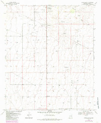
1970 Map of Tatum South
USGS Topo · Published 1972About this map
Tatum and the nearby settlement of McDonald anchor this 1970 landscape, which illustrates the intersection of ranching traditions and modern infrastructure in Lea County. The terrain is characterized by broad stretches of the Llano Estacado, where essential water sources like Camps Windmill, Keenum Windmill, and Hardrock Windmill are scattered along the natural drainage of Eightmile Draw. These windmills, often named for local ranching families, served as vital landmarks for survival and navigation across the high plains.
Find a feature on this map
15 named features on this map. Tap any name to fly to it.
Don’t see what you’re looking for? This feature index may not catch every label — zoom into the map to look around manually.
Map Details
Editions of this 1970 Tatum South Map
2 editions found
Other maps of this area

1954 · Brownfield
USGS Topo · 1:250,000

1958 · Brownfield
USGS Topo · 1:250,000

1962 · Brownfield
USGS Topo · 1:250,000

1970 · Prairieview
USGS Topo · 1:24,000

1970 · Prairieview NW
USGS Topo · 1:24,000

1970 · Gladiola
USGS Topo · 1:24,000

1970 · Simanola Valley
USGS Topo · 1:24,000

1970 · Hillburn City
USGS Topo · 1:24,000

1970 · Alston Ranch
USGS Topo · 1:24,000

1970 · Tatum North
USGS Topo · 1:24,000