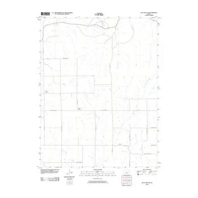
2009 Map of Alta Vista SE
USGS Topo · Published 2009About this map
Illinois Creek and the South Branch Mill Creek drainage systems define this section of the Flint Hills region at the end of the first decade of the 21st century. The map provides a detailed view of a landscape transitioning between its historical agricultural roots and contemporary resource extraction, notably at the Davis Ranch Oil Field in the north. This rural expanse is punctuated by small, significant community sites that offer critical data for genealogists, including Prairie View Cemetery, Pleasant Ridge Cemetery, and Chalk Cemetery. The road network, including uniquely named routes like Freedmen Rd and Germany Rd, suggests the diverse cultural and settlement history of Wabaunsee County. The terrain is intricately carved by several waterways, such as the Middle Branch Munkers Creek and Horse Creek, which dictate the placement of farms and crossings across the quadrangle.
Find a feature on this map
31 named features on this map. Tap any name to fly to it.
Don’t see what you’re looking for? This feature index may not catch every label — zoom into the map to look around manually.
Map Details
Editions of this 2009 Alta Vista SE Map
This is the sole edition of this map. No revisions or reprints were ever made.
Other maps of this area

1885 · Eskridge
USGS Topo · 1:125,000

1889 · Eskridge
USGS Topo · 1:125,000

1894 · Eskridge
USGS Topo · 1:125,000

1955 · Hutchinson
USGS Topo · 1:250,000

1959 · Hutchinson
USGS Topo · 1:250,000
1971 · Allendorph
USGS Topo · 1:24,000

1971 · Alta Vista SE
USGS Topo · 1:24,000

1971 · Allen
USGS Topo · 1:24,000
1971 · Volland
USGS Topo · 1:24,000

1971 · Bushong
USGS Topo · 1:24,000