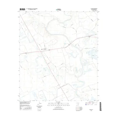
2016 Map of Altair
USGS Topo · Published 2016About this map
The settlement of Altair serves as the central hub of this mid-2010s survey, where the intersecting routes of Alt 90 and FM 102 define the local geography. The landscape is profoundly shaped by the winding course of the Colorado River, which meanders through the eastern portion of the quadrangle. This area is characterized by an intricate network of waterways and drainage features, including Skull Cr, McKenzie Cr, and the smaller Marys Br. Notable water bodies such as Muddy Lake and Heller Lake sit among the low-lying terrain, while the Leher Canal in the southwest indicates managed water systems within this coastal plain environment. The street grid of the town itself remains compact, featuring local thoroughfares like Main St, Columbus St, and Washington St that reflect the community's established layout.
Find a feature on this map
45 named features on this map. Tap any name to fly to it.
Don’t see what you’re looking for? This feature index may not catch every label — zoom into the map to look around manually.
Map Details
Editions of this 2016 Altair Map
This is the sole edition of this map. No revisions or reprints were ever made.
Other maps of this area

1953 · Seguin
USGS Topo · 1:250,000

1956 · Glidden
USGS Topo · 1:62,500

1957 · Eagle Lake
USGS Topo · 1:62,500

1957 · Altair
USGS Topo · 1:24,000

1957 · Columbus
USGS Topo · 1:24,000

1958 · Seguin
USGS Topo · 1:250,000

1958 · Alleyton
USGS Topo · 1:24,000

1959 · Garwood
USGS Topo · 1:24,000

1959 · Bonus
USGS Topo · 1:24,000
1963 · Eagle Lake
USGS Topo · 1:24,000