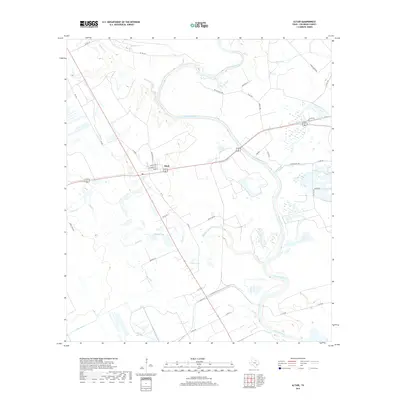
2019 Map of Altair
USGS Topo · Published 2019About this map
The settlement of Altair serves as the focal point of this Colorado County landscape, situated at the junction of Main St and Columbus St. The geography is dominated by the meandering course of the Colorado River, which carves a wide path across the northern and eastern portions of the quadrangle. This area is characterized by a complex network of waterways and low-lying features, including Muddy Lake and Heller Lake, alongside numerous tributaries like McKenzie Cr and Skull Cr. To the southwest, the presence of the Leher Canal indicates a managed approach to the region's water resources for agricultural or industrial use. The map also documents a dense grid of rural roads and family-named routes such as Thomas Dryer Rd and Pecan Valley Rd, reflecting the established land divisions and ranching connections of this Texas river valley region.
Find a feature on this map
44 named features on this map. Tap any name to fly to it.
Don’t see what you’re looking for? This feature index may not catch every label — zoom into the map to look around manually.
Map Details
Editions of this 2019 Altair Map
This is the sole edition of this map. No revisions or reprints were ever made.
Other maps of this area

1953 · Seguin
USGS Topo · 1:250,000

1956 · Glidden
USGS Topo · 1:62,500

1957 · Eagle Lake
USGS Topo · 1:62,500

1957 · Altair
USGS Topo · 1:24,000

1957 · Columbus
USGS Topo · 1:24,000

1958 · Seguin
USGS Topo · 1:250,000

1958 · Alleyton
USGS Topo · 1:24,000

1959 · Garwood
USGS Topo · 1:24,000

1959 · Bonus
USGS Topo · 1:24,000
1963 · Eagle Lake
USGS Topo · 1:24,000