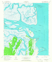
1954 Map of Altamaha Sound
USGS Topo · Published 1967About this map
Wolf Island National Wildlife Refuge dominates the eastern coastline of this mid-century survey, showcasing a complex barrier island system where the Altamaha River meets the Atlantic Ocean. The map provides detailed coastal bathymetry and topography of the marshlands separating McIntosh and Glynn counties. Further south, the northern tip of St Simons Island reveals a landscape defined by points of interest like Butler Point and Cannons Point, both featuring an Artesian Well. The navigational importance of the region is evident through the winding path of the Intracoastal Waterway as it threads through Buttermilk Sound and past Rockdedundy Island. These tidal flats and shifting sounds reflect the dynamic estuarine environment of coastal Georgia before modern development altered much of the surrounding mainland reaches.
Find a feature on this map
34 named features on this map. Tap any name to fly to it.
Don’t see what you’re looking for? This feature index may not catch every label — zoom into the map to look around manually.
Map Details
Editions of this 1954 Altamaha Sound Map
2 editions found
Other maps of this area

1920 · Cabretta Island
USGS Topo · 1:62,500

1921 · Darien
USGS Topo · 1:62,500

1944 · Cabretta Island
USGS Topo · 1:62,500

1945 · Brunswick
USGS Topo · 1:62,500

1946 · Brunswick
USGS Topo · 1:250,000

1948 · Brunswick
USGS Topo · 1:250,000

1954 · Altamaha Sound
USGS Topo · 1:24,000
1954 · Doboy Sound
USGS Topo · 1:24,000
1954 · Ridgeville
USGS Topo · 1:24,000

1954 · Cabretta Inlet
USGS Topo · 1:24,000