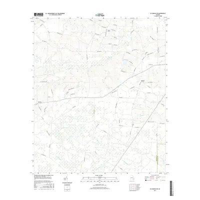
2017 Map of Altamaha SW
USGS Topo · Published 2017About this map
The small settlements of Zion, Bethel, and McTier define the rural landscape of southeast Georgia in this modern topographic survey. The area is characterized by a dense network of creek systems, including Tenmile Cr in the north and the extensive wetlands surrounding Alisons Cr and the Little Satilla Cr to the south. Local road names such as Zion Baptist Church Rd, Hershel Tillman Rd, and Maude Lamb Rd reflect the deep-rooted family history and community pillars of the region. Genealogists will find particular value in the locations of Easons Cem, Joyner Cem, and Davis Cem, which are clearly marked among the wooded tracts and agricultural parcels. The map also delineates the boundary between Appling Co and Wayne Co, following a segment of the riverine environment.
Find a feature on this map
70 named features on this map. Tap any name to fly to it.
Don’t see what you’re looking for? This feature index may not catch every label — zoom into the map to look around manually.
Map Details
Editions of this 2017 Altamaha SW Map
This is the sole edition of this map. No revisions or reprints were ever made.
Other maps of this area

1953 · Waycross
USGS Topo · 1:250,000

1958 · Waycross
USGS Topo · 1:250,000
1970 · Altamaha
USGS Topo · 1:24,000

1970 · Baxley NE
USGS Topo · 1:24,000
1970 · Altamaha SE
USGS Topo · 1:24,000
1970 · Altamaha SW
USGS Topo · 1:24,000
1970 · Tison
USGS Topo · 1:24,000

1970 · Baxley
USGS Topo · 1:24,000
1971 · Odum
USGS Topo · 1:24,000

1971 · Surrency
USGS Topo · 1:24,000