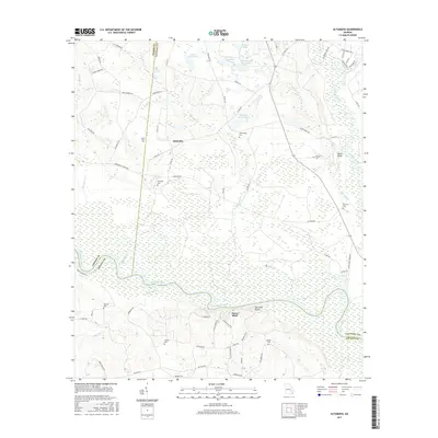
2017 Map of Altamaha
USGS Topo · Published 2017About this map
The Altamaha River serves as the dominant geographical and political boundary on this map, separating Toombs, Tattnall, and Appling counties. High riverbanks are marked by distinctive landmarks such as Eason Bluff, Iron Mine Bluff, and Moon Bluff, overlooking a landscape heavily defined by wetlands and secondary waterways like Slaughter Cr and Four Acre Cr. The small settlement of Altamaha sits north of the river, surrounded by numerous family-named burial sites including Harden Cem, Stripling Cem, and Harris Cem.
Find a feature on this map
76 named features on this map. Tap any name to fly to it.
Don’t see what you’re looking for? This feature index may not catch every label — zoom into the map to look around manually.
Map Details
Editions of this 2017 Altamaha Map
This is the sole edition of this map. No revisions or reprints were ever made.
Other maps of this area

1953 · Waycross
USGS Topo · 1:250,000

1957 · Macon
USGS Topo · 1:250,000

1958 · Macon
USGS Topo · 1:250,000

1958 · Waycross
USGS Topo · 1:250,000

1964 · Macon
USGS Topo · 1:250,000

1970 · Johnson Corner
USGS Topo · 1:24,000

1970 · Reidsville West
USGS Topo · 1:24,000
1970 · Reidsville East
USGS Topo · 1:24,000
1970 · Altamaha
USGS Topo · 1:24,000

1970 · Baxley NE
USGS Topo · 1:24,000