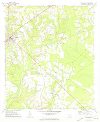
1970 Map of Reidsville East
USGS Topo · Published 1973About this map
Reidsville serves as the primary hub on this Tattnall County landscape, where small rural communities like Hughland are connected by a network of local roads and jeep trails. The terrain is defined by the drainage of Thomas Creek and Battle Creek, which feeds into Jones Millpond in the southern portion of the quadrangle. This 1970 field check documents a high density of small family and community burial grounds, including the Maddox Cem, Smith Cem, and Old Shiloh Cem, alongside active local congregations at Shady Grove Ch and Pine Grove Ch. The presence of the Tootle Airport and a prominent Lookout Tower near the town center reflects the mid-century infrastructure supporting both local aviation and forestry management in this part of Georgia.
Find a feature on this map
24 named features on this map. Tap any name to fly to it.
Don’t see what you’re looking for? This feature index may not catch every label — zoom into the map to look around manually.
Map Details
Editions of this 1970 Reidsville East Map
2 editions found
Other maps of this area

1919 · Claxton
USGS Topo · 1:62,500

1920 · Glennville
USGS Topo · 1:62,500

1944 · Claxton
USGS Topo · 1:62,500

1944 · Glennville
USGS Topo · 1:62,500

1946 · Brunswick
USGS Topo · 1:250,000

1947 · Savannah
USGS Topo · 1:250,000

1948 · Brunswick
USGS Topo · 1:250,000

1948 · Savannah
USGS Topo · 1:250,000

1950 · Glennville
USGS Topo · 1:62,500

1950 · Claxton
USGS Topo · 1:62,500