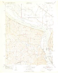
1948 Map of Altenburg
USGS Topo · Published 1948About this map
The Mississippi River creates a dynamic border between Perry County and Jackson County in this 1940s topography. On the Missouri side, the German-heritage settlements of Altenburg, Frohna, and Wittenberg anchor the landscape, connected by a network of winding roads and rugged hollows like Boone Hill Hollow and Sawmill Hollow. The riverbanks are marked by historic points such as Star Landing, Leimbach Landing, and Brunkhorst Landing, reflecting a river-based commerce that operated alongside the St Louis San Francisco railroad. Across the water in Illinois, the distinctive Fountain Bluff rises near the community of Neunert, while the Illinois Central line serves the town of Grand Tower. This era captures a rural interior still dotted with one-room institutions like Union Sch and Ridge Sch, and navigation landmarks like the prominent Tower Rock and the Backbone limestone ridge.
Find a feature on this map
43 named features on this map. Tap any name to fly to it.
Don’t see what you’re looking for? This feature index may not catch every label — zoom into the map to look around manually.
Map Details
Editions of this 1948 Altenburg Map
2 editions found
Other maps of this area

1910 · Murphysboro
USGS Topo · 1:62,500

1916 · Campbell Hill
USGS Topo · 1:62,500

1918 · Altenburg
USGS Topo · 1:62,500

1918 · Campbell Hill
USGS Topo · 1:62,500

1924 · Alto Pass
USGS Topo · 1:62,500

1925 · Altenburg
USGS Topo · 1:62,500

1938 · Murphysboro
USGS Topo · 1:62,500

1947 · Alto Pass
USGS Topo · 1:62,500

1947 · Crosstown
USGS Topo · 1:24,000

1947 · Oak Ridge
USGS Topo · 1:24,000