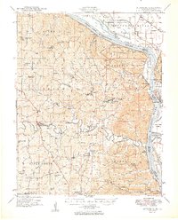
1949 Map of Altenburg
USGS Topo · Published 1949About this map
The Mississippi River creates a dynamic eastern boundary for this survey, where the river's path is marked by features like Tower Island Chute and Grand Tower Island. Inland, the landscape of Perry and Cape Girardeau counties is defined by a dense network of small rural communities and German-settled townships. The presence of numerous local schools, such as Fiehler Sch and Buckeye Sch, alongside New Bethel Ch and Zion Ch, indicates a stable, agrarian society centered around parish and neighborhood life. Transportation in the late 1940s relied on the St Louis San Francisco railroad and numerous river landings like Hines Landing and Neelys Landing, which connected these interior settlements to the broader river economy. Deep ravines such as Boone Hill Hollow and prominent elevations like Fountain Bluff across the water in Illinois add significant topographic character to the river valley corridor.
Find a feature on this map
89 named features on this map. Tap any name to fly to it.
Don’t see what you’re looking for? This feature index may not catch every label — zoom into the map to look around manually.
Map Details
Editions of this 1949 Altenburg Map
3 editions found
Other maps of this area

1910 · Murphysboro
USGS Topo · 1:62,500

1915 · Chester
USGS Topo · 1:62,500

1916 · Campbell Hill
USGS Topo · 1:62,500

1918 · Altenburg
USGS Topo · 1:62,500

1918 · Campbell Hill
USGS Topo · 1:62,500

1920 · Jonesboro
USGS Topo · 1:62,500

1922 · Cape Girardeau
USGS Topo · 1:62,500

1923 · Jonesboro
USGS Topo · 1:62,500

1923 · Perryville
USGS Topo · 1:62,500

1924 · Cape Girardeau
USGS Topo · 1:62,500