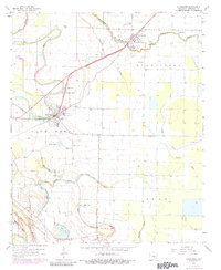
1964 Map of Altheimer
USGS Topo · Published 1984About this map
Altheimer and Wabbaseka anchor this 1960s landscape, where the St Louis Southwestern railroad cuts a diagonal line across the Jefferson County delta. The region is defined by its complex hydrology, with the winding Flat Bayou and Wabbaseka Bayou feeding into a network of oxbows and depressions like Lake Dick and Five Forks Lake. This era shows a community structured around its spiritual and educational centers, including Martha High Sch and Walker High Sch, alongside numerous rural houses of worship such as Tabernacle Ch and Jerusalem Ch. The abundance of family-named cemeteries, from Turrentine Cem to Bloomy Shade Cem, provides a detailed record of the local population. Further south, the Old Channel Plum Bayou reflects the shifting nature of the local waterways, while a small Landing Strip and the Wabbaseka Airport suggest the importance of aerial access for agricultural operations in the mid-century South.
Find a feature on this map
41 named features on this map. Tap any name to fly to it.
Don’t see what you’re looking for? This feature index may not catch every label — zoom into the map to look around manually.
Map Details
Editions of this 1964 Altheimer Map
3 editions found
Other maps of this area

1935 · Altheimer
USGS Topo · 1:62,500

1935 · Varner
USGS Topo · 1:62,500

1935 · Noble Lake
USGS Topo · 1:62,500

1941 · Goldman
USGS Topo · 1:62,500

1948 · Helena
USGS Topo · 1:250,000

1950 · Helena
USGS Topo · 1:250,000

1955 · Helena
USGS Topo · 1:250,000

1959 · Helena
USGS Topo · 1:250,000

1960 · Helena
USGS Topo · 1:250,000
1963 · Sherrill
USGS Topo · 1:24,000