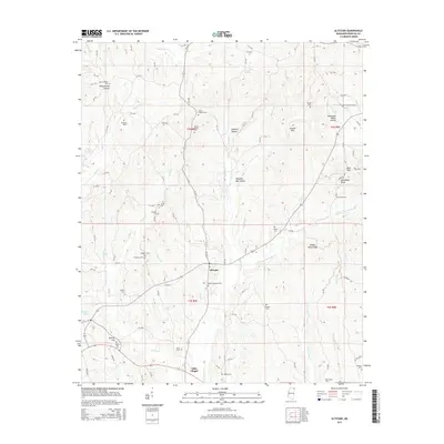
2015 Map of Altitude
USGS Topo · Published 2015About this map
The settlement of Altitude and the community of Hills Chapel anchor this Prentiss County survey, where the ridge of the Tennessee Valley Divide splits the local drainage. Numerous family burial sites dot the landscape, including the New Candler Cem, Jones Chapel Cem, and Rhodes Cem, providing a dense network of location data for genealogical research. The terrain is defined by a series of narrow valleys and hollows such as Piney Grove Hollow and Big Rock Hollow, through which streams like Big Brown Cr and Martin Cr flow. This 2015 study illustrates the enduring rural character of northeastern Mississippi, where modern county roads trace older paths through the hills, connecting long-established family landmarks and small hilltop clearings like Round Hill and Blue Hill.
Find a feature on this map
106 named features on this map. Tap any name to fly to it.
Don’t see what you’re looking for? This feature index may not catch every label — zoom into the map to look around manually.
Map Details
Editions of this 2015 Altitude Map
This is the sole edition of this map. No revisions or reprints were ever made.
Other maps of this area

1921 · Booneville
USGS Topo · 1:48,000

1922 · Booneville
USGS Topo · 1:62,500

1935 · Holcut
USGS Topo · 1:24,000

1935 · Leedy
USGS Topo · 1:24,000

1935 · Glens
USGS Topo · 1:24,000

1950 · Corinth
USGS Topo · 1:62,500

1950 · Paden
USGS Topo · 1:24,000
1950 · Burnsville
USGS Topo · 1:24,000

1950 · Glens
USGS Topo · 1:24,000

1950 · Altitude
USGS Topo · 1:24,000