
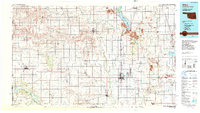
1985 Map of Altus
USGS Topo · Published 1985About this map
Altus Air Force Base dominates the central landscape of this southwest Oklahoma region, situated just east of the city of Altus. The 1980s landscape is defined by the convergence of major rail lines and the winding paths of the Elm Fork Red River, North Fork Red River, and Salt Fork Red River. This era shows a well-developed water management system, including the Altus Canal, Altus Lake, and the Tom Steed Reservoir at the edge of Great Plains State Park.
Find a feature on this map
83 named features on this map. Tap any name to fly to it.
Don’t see what you’re looking for? This feature index may not catch every label — zoom into the map to look around manually.
Map Details
Editions of this 1985 Altus Map
2 editions found
Other maps of this area

1949 · Cooperton
USGS Topo · 1:62,500

1950 · Snyder
USGS Topo · 1:62,500

1954 · Amarillo
USGS Topo · 1:250,000

1954 · Plainview
USGS Topo · 1:250,000

1955 · Lawton
USGS Topo · 1:250,000

1955 · Clinton
USGS Topo · 1:250,000

1956 · Glen Mountains
USGS Topo · 1:24,000

1956 · Manitou
USGS Topo · 1:24,000

1956 · Snyder
USGS Topo · 1:24,000

1956 · Rainy Mountain Creek
USGS Topo · 1:24,000