
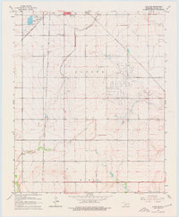
1963 Map of Altus SE
USGS Topo · Published 1965About this map
The Atchison Topeka and Santa Fe railroad runs north-south through this Jackson County landscape, reflecting the heavy reliance on rail transport in the mid-20th century. Bordering the southern edge of Altus, the map reveals early suburban developments like Lincoln Park alongside essential infrastructure, including the extensive Altus Canal and multiple Sewage Disposal Ponds. The presence of three major rail lines, including the St Louis - San Francisco and Missouri - Kansas - Texas, highlights the area's importance as a regional transportation hub.
Find a feature on this map
18 named features on this map. Tap any name to fly to it.
Don’t see what you’re looking for? This feature index may not catch every label — zoom into the map to look around manually.
Map Details
Editions of this 1963 Altus SE Map
2 editions found
Other maps of this area

1955 · Lawton
USGS Topo · 1:250,000

1958 · Frederick
USGS Topo · 1:62,500

1958 · Elmer
USGS Topo · 1:62,500

1964 · Martha
USGS Topo · 1:24,000

1964 · Altus
USGS Topo · 1:24,000

1964 · Tipton
USGS Topo · 1:24,000

1964 · Olustee
USGS Topo · 1:24,000

1964 · Headrick
USGS Topo · 1:24,000

1975 · Elmore City NE
USGS Topo · 1:24,000

1975 · Frederick NW
USGS Topo · 1:24,000