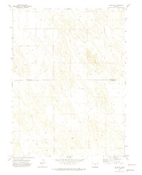
1971 Map of Alvin NW
USGS Topo · Published 1974About this map
High plains topography and remote infrastructure define this 1971 survey of the borderlands between Phillips Co and Yuma Co. The landscape is dominated by a recurring pattern of numerous small depressions and isolated water points marked simply as Well, indicating the critical nature of groundwater for this arid agricultural region. A notable family-named landmark, Vogus, sits toward the southern portion of the sheet, likely representing a local ranch or historic homestead. A long Pipeline cuts across the southwestern sections, tracing a straight line through the undulating terrain. This map captures a specialized rural environment where human presence is sparse and focused on the essential resources required for high-plains ranching and farming during the early 1970s.
Find a feature on this map
4 named features on this map. Tap any name to fly to it.
Don’t see what you’re looking for? This feature index may not catch every label — zoom into the map to look around manually.
Map Details
Editions of this 1971 Alvin NW Map
3 editions found
Other maps of this area

1954 · Sterling
USGS Topo · 1:250,000

1958 · Sterling
USGS Topo · 1:250,000

1971 · Amherst SW
USGS Topo · 1:24,000

1971 · Holyoke
USGS Topo · 1:24,000

1971 · Alvin NW
USGS Topo · 1:24,000

1971 · Amherst SE
USGS Topo · 1:24,000

1971 · Alvin SW
USGS Topo · 1:24,000

1971 · Wauneta NE
USGS Topo · 1:24,000

1971 · Alvin
USGS Topo · 1:24,000

1971 · Wauneta
USGS Topo · 1:24,000