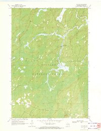
1970 Map of Alvin SW
USGS Topo · Published 1972About this map
Nicolet National Forest lands dominate this northern Wisconsin landscape, split between the townships of Hiles and Argonne. The map documents a heavily managed wilderness in the early 1970s, where recreational infrastructure like the Pine River Campground and a riverside Boat Ramp sit alongside the remnants of industrial history. A prominent Railroad Grade cuts through the western sections, marking the path of former logging operations that once defined the regional economy.
Find a feature on this map
20 named features on this map. Tap any name to fly to it.
Don’t see what you’re looking for? This feature index may not catch every label — zoom into the map to look around manually.
Map Details
Editions of this 1970 Alvin SW Map
2 editions found
Other maps of this area

1928 · Three Lakes
USGS Topo · 1:48,000

1938 · Alvin
USGS Topo · 1:48,000

1938 · Three Lakes
USGS Topo · 1:48,000

1939 · Crandon
USGS Topo · 1:48,000

1940 · Monico
USGS Topo · 1:48,000

1941 · Crandon
USGS Topo · 1:48,000

1945 · Three Lakes
USGS Topo · 1:48,000

1946 · Alvin
USGS Topo · 1:48,000

1947 · Crandon
USGS Topo · 1:48,000

1950 · Monico
USGS Topo · 1:48,000