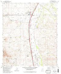
1981 Map of Amado
USGS Topo · Published 1981About this map
Amado sits at the heart of this southern Arizona landscape, where the Santa Cruz River valley meets the arid foothills of the Tumacacori Mountains. During the early 1980s, the area's development was defined by the Interstate 19 corridor, punctuated by interchanges such as the Arivaca-Amado Interchange and Agua Linda-Amado Interchange. The map reveals a transition from traditional ranching operations like the Sopori Ranch and Agua Linda to modern additions such as Greyhound Park.
Find a feature on this map
45 named features on this map. Tap any name to fly to it.
Don’t see what you’re looking for? This feature index may not catch every label — zoom into the map to look around manually.
Map Details
Editions of this 1981 Amado Map
2 editions found
Other maps of this area

1904 · Patagonia
USGS Topo · 1:125,000

1905 · Patagonia
USGS Topo · 1:125,000

1920 · Arivaca
USGS Topo · 1:125,000

1922 · Agus Caliente
USGS Topo · 1:62,500

1925 · Samaniego Peak
USGS Topo · 1:62,500

1926 · Helvetia
USGS Topo · 1:62,500

1939 · Twin Buttes
USGS Topo · 1:62,500

1939 · Tubac
USGS Topo · 1:62,500

1941 · Twin Buttes
USGS Topo · 1:62,500

1943 · Tubac
USGS Topo · 1:62,500