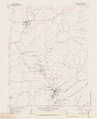
1962 Map of Amador City
USGS Topo · Published 1963About this map
Gold mining operations define the landscape of this Mother Lode corridor in the early 1960s, showing a dense concentration of quartz mines and tunnels stretching between Sutter Creek and Plymouth. The map documents the extensive industrial footprint of the era, from the massive Old Eureka Mine and Central Eureka Mine near Sutter Hill to the Keystone Mine and Bunker Hill Mine further north. Extensive areas marked as Tailings and the presence of a complex Aqueduct, Canal, and Ditch system highlight the massive scale of earth and water movement required for regional mineral extraction.
Find a feature on this map
60 named features on this map. Tap any name to fly to it.
Don’t see what you’re looking for? This feature index may not catch every label — zoom into the map to look around manually.
Map Details
Editions of this 1962 Amador City Map
4 editions found
Other maps of this area

1889 · Jackson
USGS Topo · 1:125,000

1891 · Placerville
USGS Topo · 1:125,000

1892 · Jackson
USGS Topo · 1:125,000

1892 · Placerville
USGS Topo · 1:125,000

1893 · Placerville
USGS Topo · 1:125,000

1897 · Jackson
USGS Topo · 1:125,000

1902 · Jackson
USGS Topo · 1:125,000

1941 · Sutter Creek
USGS Topo · 1:62,500

1944 · Sutter Creek
USGS Topo · 1:62,500

1947 · Sacramento
USGS Topo · 1:250,000