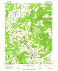
1962 Map of Amador City
USGS Topo · Published 1963About this map
Gold mining operations and small Mother Lode settlements dominate this landscape during the early 1960s. Plymouth and Sutter Creek anchor the north and south, connected by a network of roads that trace the Mother Lode's rich geological veins. The map reveals the industrial footprint of the region's historic wealth, featuring numerous named sites such as the Empire Mine, Keystone Mine, and Bunker Hill Mine. Water management is central to the area's geography, shown through the presence of an Aqueduct, various siphons, and a complex system of ditches and fumes that serviced both mining and local needs.
Find a feature on this map
62 named features on this map. Tap any name to fly to it.
Don’t see what you’re looking for? This feature index may not catch every label — zoom into the map to look around manually.
Map Details
Editions of this 1962 Amador City Map
4 editions found
Other maps of this area

1889 · Jackson
USGS Topo · 1:125,000

1891 · Placerville
USGS Topo · 1:125,000

1892 · Jackson
USGS Topo · 1:125,000

1892 · Placerville
USGS Topo · 1:125,000

1893 · Placerville
USGS Topo · 1:125,000

1897 · Jackson
USGS Topo · 1:125,000

1902 · Jackson
USGS Topo · 1:125,000

1941 · Sutter Creek
USGS Topo · 1:62,500

1944 · Sutter Creek
USGS Topo · 1:62,500

1947 · Sacramento
USGS Topo · 1:250,000