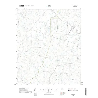
2020 Map of Ambrose
USGS Topo · Published 2020About this map
Ambrose and Wray sit at the heart of this Coffee County landscape, where the agricultural grid is defined by a dense network of family-named roads and rural cemeteries. The headwaters of Satilla Cr and the Seventeen Mile River wind through the terrain, flanked by numerous small lakes such as C Paulk Lake and Pope Lake. This 2020 map documents a transition point for South Georgia, showing the enduring presence of local landmarks like Old Coffee Rd alongside newer residential patterns. Genealogists will find significant value in the distribution of family burial grounds, including the Smith Cem, Paulk Cem, and Harper Cem, which are scattered throughout the region. The map also reveals the local water-management history with features like Evans Lake North and Jowers Lake South serving as focal points for the surrounding farmsteads.
Find a feature on this map
97 named features on this map. Tap any name to fly to it.
Don’t see what you’re looking for? This feature index may not catch every label — zoom into the map to look around manually.
Map Details
Editions of this 2020 Ambrose Map
This is the sole edition of this map. No revisions or reprints were ever made.
Other maps of this area

1953 · Waycross
USGS Topo · 1:250,000

1958 · Waycross
USGS Topo · 1:250,000

1972 · Broxton North
USGS Topo · 1:24,000

1972 · Fitzgerald East
USGS Topo · 1:24,000

1972 · Lax
USGS Topo · 1:24,000

1972 · Ambrose
USGS Topo · 1:24,000

1972 · Ocilla East
USGS Topo · 1:24,000

1972 · Mora
USGS Topo · 1:24,000

1977 · Osierfield
USGS Topo · 1:24,000
1977 · Mora
USGS Topo · 1:24,000