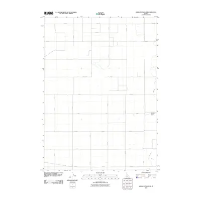
2010 Map of American Falls NW
USGS Topo · Published 2010About this map
The Aberdeen Municipal Airport stands as a primary landmark in this rural landscape of Bingham County, located just west of the Snake River plain. This territory is defined by a rigorous grid of section-line roads, such as Strang Rd and Jensen Rd, which segment the terrain into uniform agricultural plots. The reliance on managed water systems is evident through the path of the Highline Canal and its associated Lateral O, which cut diagonally across the otherwise rectilinear road network. This infrastructure highlights the intensive irrigation required to transform the high desert into productive farmland. While the map is dominated by local routes like Gambill Rd and Oak Rd, it provides a clear view of the organized settlement patterns and the essential water-moving arteries that sustain the region's economy.
Find a feature on this map
25 named features on this map. Tap any name to fly to it.
Don’t see what you’re looking for? This feature index may not catch every label — zoom into the map to look around manually.
Map Details
Editions of this 2010 American Falls NW Map
This is the sole edition of this map. No revisions or reprints were ever made.
Other maps of this area

1934 · American Falls
USGS Topo · 1:62,500

1936 · American Falls
USGS Topo · 1:62,500

1954 · Pocatello
USGS Topo · 1:250,000

1955 · Idaho Falls
USGS Topo · 1:250,000

1958 · Idaho Falls
USGS Topo · 1:250,000

1958 · Pocatello
USGS Topo · 1:250,000
1971 · American Falls SW
USGS Topo · 1:24,000
1971 · Aberdeen
USGS Topo · 1:24,000

1971 · American Falls NW
USGS Topo · 1:24,000
1971 · American Falls
USGS Topo · 1:24,000