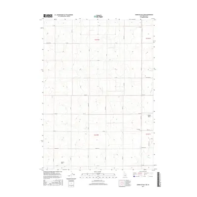
2017 Map of American Falls NW
USGS Topo · Published 2017About this map
Pleasant Valley and the surrounding agricultural lands of Bingham County are defined by a meticulous grid of rural roads and essential irrigation infrastructure. The landscape is marked by the Highline Canal and secondary distribution channels like Lateral K and Lateral O, which sustain the high-desert farming economy of this region. Human settlement and community history are anchored by the Homestead Cem and the small enclave at Pleasant Valley, while the Aberdeen Municipal Airport serves as a modern transport hub for the local area. The surveying of this quadrangle, including the townships of t5s r30e and t6s r30e, reveals a deeply organized system of section roads such as Vanderford Rd and Homestead Rd that provide access to family holdings and remote ranch lands.
Find a feature on this map
35 named features on this map. Tap any name to fly to it.
Don’t see what you’re looking for? This feature index may not catch every label — zoom into the map to look around manually.
Map Details
Editions of this 2017 American Falls NW Map
This is the sole edition of this map. No revisions or reprints were ever made.
Other maps of this area

1934 · American Falls
USGS Topo · 1:62,500

1936 · American Falls
USGS Topo · 1:62,500

1954 · Pocatello
USGS Topo · 1:250,000

1955 · Idaho Falls
USGS Topo · 1:250,000

1958 · Idaho Falls
USGS Topo · 1:250,000

1958 · Pocatello
USGS Topo · 1:250,000
1971 · American Falls SW
USGS Topo · 1:24,000
1971 · Aberdeen
USGS Topo · 1:24,000

1971 · American Falls NW
USGS Topo · 1:24,000
1971 · American Falls
USGS Topo · 1:24,000