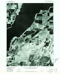
1976 Map of American Falls
USGS Topo · Published 1980About this map
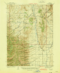
American Falls and its surrounding agricultural landscape are captured in this 1976 orthophotoquad, which utilizes aerial imagery to document the interface between high-desert irrigation and the massive American Falls Reservoir. The grid-like pattern of local farming abruptly meets the irregular shoreline of the reservoir, illustrating the mid-century water management systems that transformed this portion of Idaho. To the south, the terrain rises toward the distinct peaks of Paps Mtn, while Sunbeam Creek cuts through the southeastern uplands. Unlike standard topographic maps, this photographic survey provides researchers with a literal view of the vegetation, field boundaries, and urban density of American Falls as it appeared during the nation's bicentennial year.
Find a feature on this map
4 named features on this map. Tap any name to fly to it.
Don’t see what you’re looking for? This feature index may not catch every label — zoom into the map to look around manually.
Map Details
Editions of this 1976 American Falls Map
This is the sole edition of this map. No revisions or reprints were ever made.
Other maps of this area

1934 · American Falls
USGS Topo · 1:62,500

1934 · Michaud
USGS Topo · 1:62,500
1934 · Rockland
USGS Topo · 1:62,500

1936 · American Falls
USGS Topo · 1:62,500
1937 · Rockland
USGS Topo · 1:62,500

1937 · Michaud
USGS Topo · 1:62,500
1938 · Pauline
USGS Topo · 1:48,000
1944 · Arbon
USGS Topo · 1:62,500

1954 · Pocatello
USGS Topo · 1:250,000

1958 · Pocatello
USGS Topo · 1:250,000