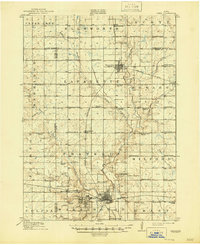
1914 Map of Ames
USGS Topo · Published 1946About this map
The growing campus of Iowa State College anchors the southern portion of this 1912 survey, appearing as a focal point of development just west of Ames. The landscape is defined by the confluence of Squaw Creek and the Skunk River, where a grid of rural schools reveals the dense population of farming families during this era. Named for early settlers, these one-room schoolhouses like Tiernagel School, Sjurson School, and Espeland School served the townships of Ellsworth and Scott. Transport networks are well-established, with the Chicago and Northwestern and Minneapolis and St. Louis railroads connecting agricultural hubs like Story City, Roland, and Gilbert. The map provides a detailed view of the terrain before mid-century expansion, capturing the early layout of Ontario and the scattered farmsteads that once dotted the banks of Keigley Branch and Indian Creek.
Find a feature on this map
77 named features on this map. Tap any name to fly to it.
Don’t see what you’re looking for? This feature index may not catch every label — zoom into the map to look around manually.
Map Details
Editions of this 1914 Ames Map
3 editions found
Other maps of this area

1911 · Madrid
USGS Topo · 1:62,500

1911 · Slater
USGS Topo · 1:62,500

1912 · Ames
USGS Topo · 1:62,500

1913 · Slater
USGS Topo · 1:62,500

1914 · Madrid
USGS Topo · 1:62,500

1914 · Ames
USGS Topo · 1:62,500

1916 · Boone
USGS Topo · 1:62,500

1954 · Waterloo
USGS Topo · 1:250,000

1954 · Des Moines
USGS Topo · 1:250,000

1955 · Waterloo
USGS Topo · 1:250,000