
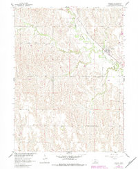
1961 Map of Amherst
USGS Topo · Published 1963About this map
The village of Amherst serves as the primary hub of this 1961 survey, situated at the junction of the Union Pacific railroad and the meandering Wood River. The landscape is a study in Nebraska agricultural development during the mid-twentieth century, with the terrain divided into named sections such as Logan, Grant, and Elm Creek. A notable genealogical landmark, the Stanley Cem, is located southeast of the main settlement along the riverbank. This map highlights an intricate network of irrigation wells across the river valley, reflecting the area's transition to intensive water management. The survey, conducted for the development of the Missouri River Basin, meticulously records fence lines and field boundaries, providing researchers with a precise layout of rural land use before modern consolidated farming practices further altered the local geography.
Find a feature on this map
14 named features on this map. Tap any name to fly to it.
Don’t see what you’re looking for? This feature index may not catch every label — zoom into the map to look around manually.
Map Details
Editions of this 1961 Amherst Map
2 editions found
Other maps of this area

1894 · Kearney
USGS Topo · 1:62,500

1896 · Kearney
USGS Topo · 1:125,000

1955 · Grand Island
USGS Topo · 1:250,000

1957 · Grand Island
USGS Topo · 1:250,000

1958 · Grand Island
USGS Topo · 1:250,000

1961 · Elm Creek West
USGS Topo · 1:24,000

1961 · Miller SW
USGS Topo · 1:24,000

1962 · Riverdale
USGS Topo · 1:24,000

1962 · Elm Creek East
USGS Topo · 1:24,000
1962 · Miller NE
USGS Topo · 1:24,000