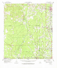
1974 Map of Amite
USGS Topo · Published 1978About this map
The Tickfaw River and Natalbany River systems define the geography of this mid-1970s landscape, where rural life is organized around parish-line settlements and numerous country churches. In the north, Amite serves as a principal hub near Oak Forest Academy, while the Illinois Central Gulf railroad links the communities of Independence, Albany, and Holden to the south. This era reflects a transition in land use, visible in the concentration of Gravel Pits and the extensive grounds of the Hammond State Sch for the Mentally Retarded. Genealogists will find a dense network of family-named landmarks and burial grounds, such as Sharkey Cem, Bankston Cem, and Courtney Cem, often situated near small congregations like Leonard Chapel or McMichael Ch. The map captures the intricate drainage patterns of the Florida Parishes, from Hog Bayou to the winding Bear Creek.
Find a feature on this map
141 named features on this map. Tap any name to fly to it.
Don’t see what you’re looking for? This feature index may not catch every label — zoom into the map to look around manually.
Map Details
Editions of this 1974 Amite Map
This is the sole edition of this map. No revisions or reprints were ever made.
Other maps of this area

1934 · Denham Springs
USGS Topo · 1:62,500

1934 · Springfield
USGS Topo · 1:62,500

1935 · Ponchatoula
USGS Topo · 1:62,500

1939 · Ponchatoula
USGS Topo · 1:62,500

1939 · Springfield
USGS Topo · 1:62,500

1939 · Denham Springs
USGS Topo · 1:62,500

1940 · Tickfaw
USGS Topo · 1:31,680

1940 · Roseland
USGS Topo · 1:31,680

1941 · Gilead
USGS Topo · 1:31,680

1942 · Roseland
USGS Topo · 1:31,680