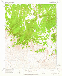
1961 Map of Ammonia Tanks
USGS Topo · Published 1962About this map
Nevada Test Site boundaries dominate the central landscape of this 1961 topographical study, conducted in cooperation with the Atomic Energy Commission. The map details a high-altitude desert environment characterized by the broad volcanic plateaus of Pahute Mesa and Buckboard Mesa, separated by the deep incision of Silent Canyon. This era of mapping captured the area as it was being actively utilized for national security purposes, showing a network of primitive transportation routes including the Back Road and various unnamed Jeep Trails that traverse the arid terrain.
Find a feature on this map
11 named features on this map. Tap any name to fly to it.
Don’t see what you’re looking for? This feature index may not catch every label — zoom into the map to look around manually.
Map Details
Editions of this 1961 Ammonia Tanks Map
2 editions found
Other maps of this area

1908 · Kawich
USGS Topo · 1:250,000

1942 · Wheelbarrow Peak
USGS Topo · 1:125,000

1952 · Tippipah Spring
USGS Topo · 1:62,500

1952 · Timber Mountain
USGS Topo · 1:62,500

1952 · Wheelbarrow Peak
USGS Topo · 1:62,500

1952 · Silent Canyon
USGS Topo · 1:62,500

1954 · Goldfield
USGS Topo · 1:250,000

1955 · Goldfield
USGS Topo · 1:250,000

1958 · Goldfield
USGS Topo · 1:250,000
1960 · Tippipah Spring
USGS Topo · 1:24,000