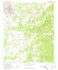
1966 Map of Amory
USGS Topo · Published 1981About this map
Amory serves as a significant rail hub in the mid-1960s, defined by the junction of the Mississippian and St Louis-San Francisco railroads. The town's infrastructure reflects this industrial importance, with a notable Roundhouse and an organized grid of streets like Middle St and Walnut St. Just east of the urban center, the landscape transitions into the rural communities of Hatley and Becker, where life centered around small country churches such as St Matthews Ch and Gregory Chapel.
Find a feature on this map
54 named features on this map. Tap any name to fly to it.
Don’t see what you’re looking for? This feature index may not catch every label — zoom into the map to look around manually.
Map Details
Editions of this 1966 Amory Map
3 editions found
Other maps of this area

1953 · West Point
USGS Topo · 1:250,000

1956 · Tupelo
USGS Topo · 1:250,000

1958 · Tupelo
USGS Topo · 1:250,000

1958 · West Point
USGS Topo · 1:250,000

1963 · West Point
USGS Topo · 1:250,000

1966 · Smithville
USGS Topo · 1:24,000

1966 · Aberdeen
USGS Topo · 1:24,000

1966 · Amory
USGS Topo · 1:24,000

1966 · Amory SW
USGS Topo · 1:24,000

1966 · Turon
USGS Topo · 1:24,000