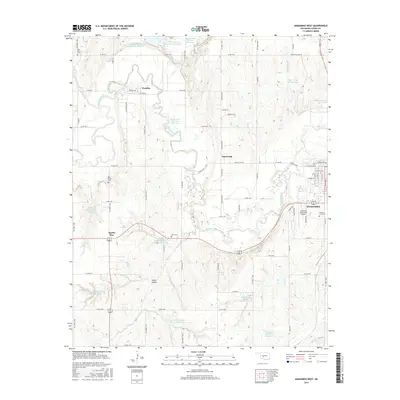
2016 Map of Anadarko West
USGS Topo · Published 2016About this map
The Washita River meanders across Caddo County, defining the agricultural landscape west of Anadarko. This region is characterized by a sophisticated network of flood control and water management features, including the Sugar Creek Site L45 Reservoir and numerous numbered reservoirs such as Public Service Reservoir Number 3. The river valley is flanked by small settlements and rural hubs like Washita and Squaretop, while the southwestern corner is marked by Apache Wye. For local historians and genealogists, the map identifies several burial grounds including Rest Haven Cem, Red Stone Cem, and Memory Lane Cem. Modern infrastructure like the Anadarko Municipal Airport and the Southwestern Power Station Reservoir contrast with the natural topography of Cedar Canyon, showing the area's development as an energy and transportation corridor in the early twenty-first century.
Find a feature on this map
76 named features on this map. Tap any name to fly to it.
Don’t see what you’re looking for? This feature index may not catch every label — zoom into the map to look around manually.
Map Details
Editions of this 2016 Anadarko West Map
This is the sole edition of this map. No revisions or reprints were ever made.
Other maps of this area

1945 · Anadarko
USGS Topo · 1:62,500

1949 · Cement
USGS Topo · 1:62,500

1951 · Fort Cobb
USGS Topo · 1:62,500

1955 · Lawton
USGS Topo · 1:250,000

1955 · Clinton
USGS Topo · 1:250,000

1956 · Boone
USGS Topo · 1:24,000
1956 · Cyril
USGS Topo · 1:24,000

1956 · Apache
USGS Topo · 1:24,000

1956 · Apache
USGS Topo · 1:62,500
1956 · Cement
USGS Topo · 1:62,500