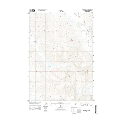
2015 Map of Anchorage A-7 NE
USGS Topo · Published 2015About this map
Eagle Peak and Hurdygurdy Mtn dominate this 2015 survey of the Chugach Mountains, where high-altitude geography is defined by permanent ice and alpine hydrology. The map details a complex glacial landscape, including the Flute Glacier and Organ Glacier, which feed the local watershed. Below these peaks, the high basins contain Eagle Lake and Symphony Lake, separated by a narrow land bridge. The drainage patterns of the S Fork Eagle River and Falling Water Cr provide a clear view of the erosion and deposition cycles in this sub-arctic environment. The presence of Crow Pass and named routes like Hiland Road and Eagle River Road reveal the points where mountain access intersects with the rising topography of the surrounding wilderness.
Find a feature on this map
25 named features on this map. Tap any name to fly to it.
Don’t see what you’re looking for? This feature index may not catch every label — zoom into the map to look around manually.
Map Details
Editions of this 2015 Anchorage A-7 NE Map
This is the sole edition of this map. No revisions or reprints were ever made.
Other maps of this area

1951 · Anchorage
USGS Topo · 1:250,000

1960 · Anchorage A-6
USGS Topo · 1:63,360

1960 · Anchorage B-7
USGS Topo · 1:63,360

1960 · Anchorage B-6
USGS Topo · 1:63,360

1960 · Anchorage A-7
USGS Topo · 1:63,360

1962 · Anchorage
USGS Topo · 1:250,000

1979 · Anchorage B-7 SW
USGS Topo · 1:25,000
1979 · Anchorage B-7 SE
USGS Topo · 1:25,000

1979 · Anchorage
USGS Topo · 1:250,000
1979 · Anchorage A-7 NE
USGS Topo · 1:25,000