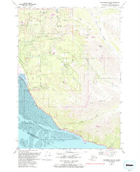
1979 Map of Anchorage A-7 NE
USGS Topo · Published 1993About this map
Chugach State Park dominates the mountainous terrain of this 1970s survey, illustrating the interface between the expanding residential fringes of the Municipality of Anchorage and the steep slopes of the Chugach Range. The map details a landscape in transition, where established neighborhood schools like Huffman Sch and O'Malley Sch serve growing communities along Huffman Road. To the south, the settlement of Potter and the small enclave at Rainbow cling to the narrow corridor between the mountains and the tidal flats of Turnagain Arm. The survey captures the early development of the Hillside area, including the Bear Valley Sch, while documenting the critical infrastructure of the Seward Highway and a major Pipeline corridor. Distinctive landmarks such as Flattop Mountain and Beluga Point provide clear orientation for tracing the geographic evolution of the region during a period of significant growth.
Find a feature on this map
40 named features on this map. Tap any name to fly to it.
Don’t see what you’re looking for? This feature index may not catch every label — zoom into the map to look around manually.
Map Details
Editions of this 1979 Anchorage A-7 NE Map
This is the sole edition of this map. No revisions or reprints were ever made.
Other maps of this area

1951 · Anchorage
USGS Topo · 1:250,000

1960 · Anchorage A-6
USGS Topo · 1:63,360

1960 · Anchorage B-7
USGS Topo · 1:63,360

1960 · Anchorage B-6
USGS Topo · 1:63,360

1960 · Anchorage A-7
USGS Topo · 1:63,360

1962 · Anchorage
USGS Topo · 1:250,000

1979 · Anchorage B-7 SW
USGS Topo · 1:25,000
1979 · Anchorage B-7 SE
USGS Topo · 1:25,000

1979 · Anchorage
USGS Topo · 1:250,000
1993 · Anchorage A-7 NE
USGS Topo · 1:25,000