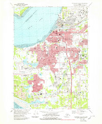
1979 Map of Anchorage A-8 NW
USGS Topo · Published 1979About this map
The growing city of Anchorage and its expanding suburban districts are captured here during a period of significant post-statehood development. The landscape is defined by its extensive aviation and military infrastructure, from the runways of Elmendorf Air Force Base and Merrill Field to the sprawl of the Anchorage International Airport and Kulis Air Nat Guard Base. Residential growth is evident in established neighborhoods like Spenard, Mountain View, and Turnagain Heights. Along the coast, Earthquake Park serves as a reminder of the region's seismic history, while the tracks of the Alaska Railroad trace the shoreline of the Knik Arm. The map reveals a high density of civic institutions, including West High Sch, Providence Hospital, and the Memorial Park (Cem), alongside numerous community spaces like Elderberry Park and Delaney Park.
Find a feature on this map
124 named features on this map. Tap any name to fly to it.
Don’t see what you’re looking for? This feature index may not catch every label — zoom into the map to look around manually.
Map Details
Editions of this 1979 Anchorage A-8 NW Map
3 editions found
Other maps of this area

1949 · Tyonek
USGS Topo · 1:250,000

1951 · Anchorage
USGS Topo · 1:250,000

1951 · Tyonek
USGS Topo · 1:250,000

1951 · Tyonek A-1
USGS Topo · 1:63,360

1952 · Tyonek A-1
USGS Topo · 1:63,360

1952 · Anchorage A-8
USGS Topo · 1:63,360

1952 · Anchorage B-8
USGS Topo · 1:63,360

1953 · Anchorage A-8
USGS Topo · 1:63,360

1953 · Anchorage B-8
USGS Topo · 1:63,360

1958 · Tyonek B-1
USGS Topo · 1:63,360