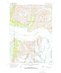
1960 Map of Anchorage B-4
USGS Topo · Published 1968About this map
Knik Glacier and its massive neighbor Marcus Baker Glacier dominate this glacial landscape at the boundary of the Matanuska-Susitna Borough and the Greater Anchorage Area Borough. The survey illustrates the complex drainage systems formed by ice and meltwater, specifically the positioning of Lower Lake George and Inner Lake George near the terminus of the Colony Glacier. At this mid-century moment, the vast Knik River valley serves as a primary corridor, with the map identifying a remote Landing Strip north of Gannett Glacier. Waterways like Metal Creek and Fourteen Creek cut through the high elevations, while the broad Grasshopper Valley provides a rare break in the ice-fields. The detailed notation of crevasses across the major ice sheets provides a historical baseline for studying the shifting morphology of the Alaskan interior prior to later-century changes.
Find a feature on this map
17 named features on this map. Tap any name to fly to it.
Don’t see what you’re looking for? This feature index may not catch every label — zoom into the map to look around manually.
Map Details
Editions of this 1960 Anchorage B-4 Map
3 editions found
Other maps of this area

1951 · Anchorage
USGS Topo · 1:250,000

1951 · Anchorage C-5
USGS Topo · 1:63,360

1952 · Anchorage C-5
USGS Topo · 1:63,360

1960 · Anchorage A-5
USGS Topo · 1:63,360

1960 · Anchorage A-4
USGS Topo · 1:63,360

1960 · Anchorage A-3
USGS Topo · 1:63,360

1960 · Anchorage C-5
USGS Topo · 1:63,360

1960 · Anchorage B-5
USGS Topo · 1:63,360

1960 · Anchorage B-4
USGS Topo · 1:63,360

1960 · Anchorage C-3
USGS Topo · 1:63,360