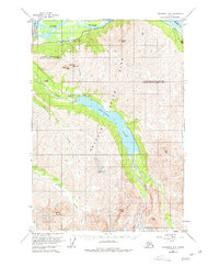
1960 Map of Anchorage B-6
USGS Topo · Published 1977About this map
Eklutna Lake dominates this portion of the northern Chugach Range, serving as a focal point for the mountain landscape south of the Knik River. The survey captures the infrastructure of the mid-20th century, including the Eklutna Powerhouse and the Eklutna Lake Landing Strip, which reflect the area's development for utility and accessibility. The transportation corridor is clearly defined in the northwest, where the Glenn Highway and the Alaska Railroad skirt the base of Pioneer Peak. Inside the boundaries of Chugach State Park, the topography rises steeply toward massive summits like Bold Peak and The Mitre. To the south, the massive Eklutna Glacier feeds the valley, illustrating the glacial processes that shaped the drainage of Thunder Bird Creek and Peters Creek.
Find a feature on this map
23 named features on this map. Tap any name to fly to it.
Don’t see what you’re looking for? This feature index may not catch every label — zoom into the map to look around manually.
Map Details
Editions of this 1960 Anchorage B-6 Map
5 editions found
Other maps of this area

1950 · Anchorage C-7
USGS Topo · 1:63,360

1951 · Anchorage
USGS Topo · 1:250,000

1951 · Anchorage C-6
USGS Topo · 1:63,360

1951 · Anchorage C-7
USGS Topo · 1:63,360

1951 · Anchorage C-5
USGS Topo · 1:63,360

1952 · Anchorage C-7
USGS Topo · 1:63,360

1952 · Anchorage C-5
USGS Topo · 1:63,360

1960 · Anchorage A-6
USGS Topo · 1:63,360

1960 · Anchorage B-7
USGS Topo · 1:63,360

1960 · Anchorage B-6
USGS Topo · 1:63,360