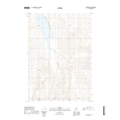
2021 Map of Anchorage B-6 SE
USGS Topo · Published 2021About this map
Eklutna Lake and the steep mountain corridors of the Chugach Mountains define this alpine landscape northeast of Anchorage. The glacial waters of the lake feed into the Eklutna River, which is flanked by a network of wilderness routes including the Eklutna Lakeside Trl and the East Fork Eklutna River Trl. High-elevation landmarks like Bold Peak, Benign Peak, and the distinctive formation known as The Mitre dominate the topography, while the Bold Ridge Trl provides access to the upper reaches of the massif. A notable point of backcountry infrastructure, Bold Airport, sits on the eastern shore of the lake, serving as a remote landing strip in an area characterized by deep valleys and sharp ridgelines. The map illustrates the contemporary state of these protected lands, showing the intersection of recreational trails and dramatic elevation changes within the township system.
Find a feature on this map
15 named features on this map. Tap any name to fly to it.
Don’t see what you’re looking for? This feature index may not catch every label — zoom into the map to look around manually.
Map Details
Editions of this 2021 Anchorage B-6 SE Map
This is the sole edition of this map. No revisions or reprints were ever made.
Other maps of this area

1951 · Anchorage
USGS Topo · 1:250,000

1960 · Anchorage A-6
USGS Topo · 1:63,360

1960 · Anchorage B-6
USGS Topo · 1:63,360

1960 · Anchorage A-5
USGS Topo · 1:63,360

1960 · Anchorage B-5
USGS Topo · 1:63,360

1962 · Anchorage
USGS Topo · 1:250,000

1979 · Anchorage B-6 NW
USGS Topo · 1:25,000

1979 · Anchorage
USGS Topo · 1:250,000
1994 · Anchorage A-6
USGS Topo · 1:63,360
1994 · Anchorage B-6
USGS Topo · 1:63,360