2023 Map of Anchorage B-6 SE
USGS Topo · Published 2023About this map
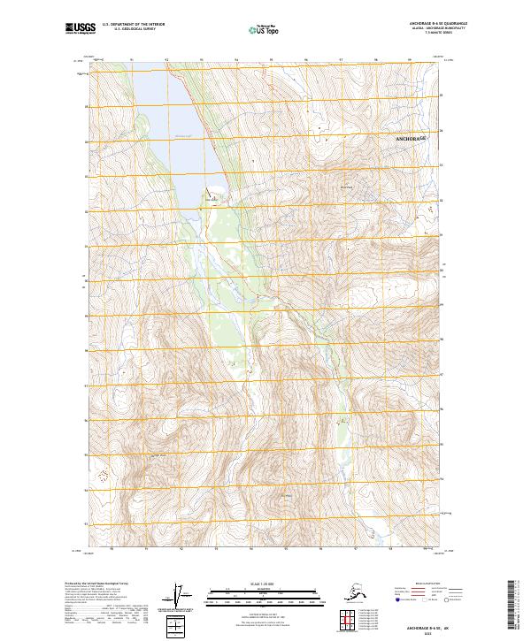
Eklutna Lake dominates the northwest corner of this map, serving as a focal point for the surrounding glacial valley. The area is defined by massive peaks including Bold Peak and Benign Peak, which rise steeply above the Eklutna River and its East Fork. Human presence is concentrated near the shoreline, where the Bold Airport and the Eklutna Lakeside Trl provide access to this high-altitude landscape. Further inland, the Bold Ridge Trl climbs toward the high ground near The Mitre. The map illustrates the specialized infrastructure required for transport and navigation in the Chugach Mountains, emphasizing the role of small airstrips and dedicated trail systems in reaching the interior of the Anchorage Municipality.
Find a feature on this map
16 named features on this map. Tap any name to fly to it.
Don’t see what you’re looking for? This feature index may not catch every label — zoom into the map to look around manually.
Map Details
Editions of this 2023 Anchorage B-6 SE Map
This is the sole edition of this map. No revisions or reprints were ever made.
Other maps of this area

1951 · Anchorage
USGS Topo · 1:250,000

1960 · Anchorage A-6
USGS Topo · 1:63,360

1960 · Anchorage B-6
USGS Topo · 1:63,360

1960 · Anchorage A-5
USGS Topo · 1:63,360

1960 · Anchorage B-5
USGS Topo · 1:63,360

1962 · Anchorage
USGS Topo · 1:250,000

1979 · Anchorage B-6 NW
USGS Topo · 1:25,000

1979 · Anchorage
USGS Topo · 1:250,000
1994 · Anchorage A-6
USGS Topo · 1:63,360
1994 · Anchorage B-6
USGS Topo · 1:63,360