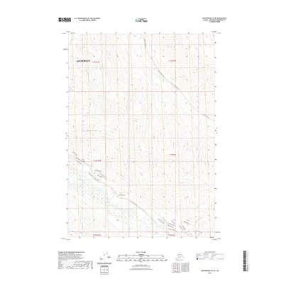
2021 Map of Anchorage B-7 SE
USGS Topo · Published 2021About this map
Mt Magnificent dominates the central terrain of this quadrangle, serving as a prominent landmark north of the Eagle River. The landscape is defined by the steep descent from high ridgelines into glacial valleys, where remote access is maintained via the Peters Creek Valley Trl and Peters Creek Trl. While much of the eastern and northern portions remain undeveloped wilderness drained by Little Peters Cr and Meadow Cr, the southwestern corner reveals modern residential expansion into the foothills. This development is evidenced by a dense network of roads such as White Spruce Drive, Zuleika Road, and Prudhoe Bay Avenue. The map illustrates the contemporary balance between protected Chugach mountain terrain and the outward growth of the Anchorage municipality along the river corridor.
Find a feature on this map
34 named features on this map. Tap any name to fly to it.
Don’t see what you’re looking for? This feature index may not catch every label — zoom into the map to look around manually.
Map Details
Editions of this 2021 Anchorage B-7 SE Map
This is the sole edition of this map. No revisions or reprints were ever made.
Other maps of this area

1951 · Anchorage
USGS Topo · 1:250,000

1960 · Anchorage A-6
USGS Topo · 1:63,360

1960 · Anchorage B-7
USGS Topo · 1:63,360

1960 · Anchorage B-6
USGS Topo · 1:63,360

1960 · Anchorage A-7
USGS Topo · 1:63,360

1962 · Anchorage
USGS Topo · 1:250,000

1979 · Anchorage B-6 NW
USGS Topo · 1:25,000

1979 · Anchorage B-7 SW
USGS Topo · 1:25,000
1979 · Anchorage B-7 SE
USGS Topo · 1:25,000
1979 · Anchorage B-7 NE
USGS Topo · 1:25,000