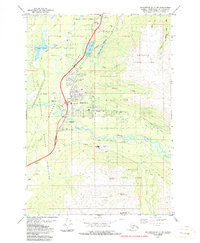
1979 Map of Anchorage B-7 SW
USGS Topo · Published 1987About this map
Eagle River sits at the center of this 1970s landscape, serving as a hub between the expanding residential areas and the surrounding wilderness of Chugach State Park. The map documents the community's infrastructure during a period of steady growth, featuring educational sites like Chugiak High Sch and Homestead Sch, alongside institutional landmarks such as the State Correctional Center. The corridor is defined by the Glenn Highway and the Alaska Railroad, which run parallel through the Moraine terrain, providing essential connectivity to the region.
Find a feature on this map
38 named features on this map. Tap any name to fly to it.
Don’t see what you’re looking for? This feature index may not catch every label — zoom into the map to look around manually.
Map Details
Editions of this 1979 Anchorage B-7 SW Map
4 editions found
Other maps of this area

1951 · Anchorage
USGS Topo · 1:250,000

1952 · Anchorage A-8
USGS Topo · 1:63,360

1952 · Anchorage B-8
USGS Topo · 1:63,360

1953 · Anchorage A-8
USGS Topo · 1:63,360

1953 · Anchorage B-8
USGS Topo · 1:63,360

1960 · Anchorage B-7
USGS Topo · 1:63,360

1960 · Anchorage A-7
USGS Topo · 1:63,360

1962 · Anchorage
USGS Topo · 1:250,000

1965 · Anchorage B-8
USGS Topo · 1:63,360

1979 · Anchorage B-7 SW
USGS Topo · 1:25,000