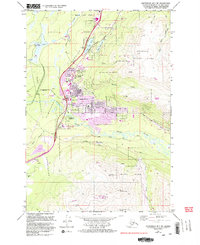
1979 Map of Anchorage B-7 SW
USGS Topo · Published 1994About this map
The community of Eagle River serves as the central hub of this 1979 survey, situated where the Glenn Highway cuts through a landscape defined by glacial moraines and the river’s winding course. This era represents a significant period of residential expansion, evidenced by numerous purple-shaded revisions indicating new housing and suburban development near Ernest Gruening Jr High Sch and Ravenwood Sch. The eastern edge of the map rises sharply into the peaks of Chugach State Park, including Mt Baldy and the prominent Mile High Saddle.
Find a feature on this map
38 named features on this map. Tap any name to fly to it.
Don’t see what you’re looking for? This feature index may not catch every label — zoom into the map to look around manually.
Map Details
Editions of this 1979 Anchorage B-7 SW Map
4 editions found
Other maps of this area

1951 · Anchorage
USGS Topo · 1:250,000

1952 · Anchorage A-8
USGS Topo · 1:63,360

1952 · Anchorage B-8
USGS Topo · 1:63,360

1953 · Anchorage A-8
USGS Topo · 1:63,360

1953 · Anchorage B-8
USGS Topo · 1:63,360

1960 · Anchorage B-7
USGS Topo · 1:63,360

1960 · Anchorage A-7
USGS Topo · 1:63,360

1962 · Anchorage
USGS Topo · 1:250,000

1965 · Anchorage B-8
USGS Topo · 1:63,360

1979 · Anchorage B-7 SW
USGS Topo · 1:25,000