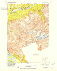
1952 Map of Anchorage C-5
USGS Topo · Published 1952About this map
The Matanuska River valley serves as the primary corridor for human activity and transport in this post-war Alaskan interior study. Located north of the Chugach Mountains, the settlement of Chickaloon is positioned near the junction of the Kings River and the newly improved Glenn Highway. This thoroughfare, marked with numerous bench marks like BM 646, traces the river's northern bank as it winds through a landscape of significant peaks including Pinnacle Mtn and Kings Mtn. To the southwest, the terrain descends toward the Knik River, where the survey notes a transition to marshier ground near VABM 202 Grass. The map also highlights the complex drainage system of the region, featuring Little Granite Creek, Carpenter Creek, and Wolverine Creek, reflecting a period when remote trail networks still provided essential access to the higher elevations of the Chugach range.
Find a feature on this map
24 named features on this map. Tap any name to fly to it.
Don’t see what you’re looking for? This feature index may not catch every label — zoom into the map to look around manually.
Map Details
Editions of this 1952 Anchorage C-5 Map
2 editions found
Other maps of this area

1948 · Anchorage D-4
USGS Topo · 1:63,360

1949 · Anchorage D-5
USGS Topo · 1:63,360

1950 · Anchorage D-6
USGS Topo · 1:63,360

1951 · Anchorage
USGS Topo · 1:250,000

1951 · Anchorage C-6
USGS Topo · 1:63,360

1951 · Anchorage C-5
USGS Topo · 1:63,360

1952 · Anchorage D-6
USGS Topo · 1:63,360

1952 · Anchorage D-5
USGS Topo · 1:63,360

1952 · Anchorage D-4
USGS Topo · 1:63,360

1952 · Anchorage C-5
USGS Topo · 1:63,360