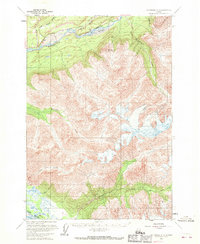
1960 Map of Anchorage C-5
USGS Topo · Published 1970About this map
Pinnacle Mountain stands as a central landmark in this Alaskan landscape, where the northern glacial drainage systems of the Matanuska River meet the southern reach of the Knik River. The geography is defined by a dense network of watercourses, including the Kings River and Carpenter Creek, which carve through the high elevations. Transportation in the mid-twentieth century was largely limited to the corridor along the Glenn Highway in the north, where a local trail also provides access to the river's edge. This 1960 field-annotated survey reveals a transition from the lower river valleys to the ice-laden peaks of the interior. The presence of numerous unnamed glaciers and high-altitude drainage basins like those of Wolverine Creek and Jim Creek illustrates the complex hydrologic character of the Chugach Mountains before more extensive modern development.
Find a feature on this map
11 named features on this map. Tap any name to fly to it.
Don’t see what you’re looking for? This feature index may not catch every label — zoom into the map to look around manually.
Map Details
Editions of this 1960 Anchorage C-5 Map
3 editions found

Other maps of this area

1948 · Anchorage D-4
USGS Topo · 1:63,360

1949 · Anchorage D-5
USGS Topo · 1:63,360

1950 · Anchorage D-6
USGS Topo · 1:63,360

1951 · Anchorage
USGS Topo · 1:250,000

1951 · Anchorage C-6
USGS Topo · 1:63,360

1951 · Anchorage C-5
USGS Topo · 1:63,360

1952 · Anchorage D-6
USGS Topo · 1:63,360

1952 · Anchorage D-5
USGS Topo · 1:63,360

1952 · Anchorage D-4
USGS Topo · 1:63,360

1952 · Anchorage C-5
USGS Topo · 1:63,360