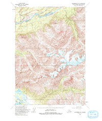
1960 Map of Anchorage C-5
USGS Topo · Published 1993About this map
The Matanuska Valley serves as the focal point of this 1960 survey, dominated by the sweeping glacial waters of the Matanuska River. Following the northern bank, the Glenn Highway provides the primary transit corridor through this high-altitude landscape, passing near the confluence of Kings River and the steep elevations of Pinnacle Mountain. The map illustrates a transition from the structured transportation route in the north to the glacial drainage systems of the south, where the Knik River and Finger Lakes emerge. Numerous tributaries, such as Little Granite Creek and Wolverine Creek, carve through the complex topography, indicating a landscape defined by significant water runoff and extreme relief. This documentation captures the area before extensive modern development, preserving the original path of the highway and the natural state of the river braids.
Find a feature on this map
12 named features on this map. Tap any name to fly to it.
Don’t see what you’re looking for? This feature index may not catch every label — zoom into the map to look around manually.
Map Details
Editions of this 1960 Anchorage C-5 Map
3 editions found

Other maps of this area

1948 · Anchorage D-4
USGS Topo · 1:63,360

1949 · Anchorage D-5
USGS Topo · 1:63,360

1950 · Anchorage D-6
USGS Topo · 1:63,360

1951 · Anchorage
USGS Topo · 1:250,000

1951 · Anchorage C-6
USGS Topo · 1:63,360

1951 · Anchorage C-5
USGS Topo · 1:63,360

1952 · Anchorage D-6
USGS Topo · 1:63,360

1952 · Anchorage D-5
USGS Topo · 1:63,360

1952 · Anchorage D-4
USGS Topo · 1:63,360

1952 · Anchorage C-5
USGS Topo · 1:63,360