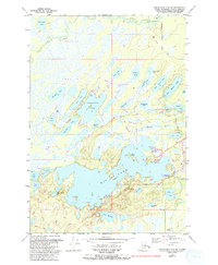
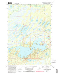
1979 Map of Anchorage C-8 SW
USGS Topo · Published 1993About this map
The complex shoreline of Big Lake dominates this landscape in the Matanuska-Susitna Borough, illustrating a region defined by its dense network of interconnected waterways and recreational developments. During the late 1970s and through the early 1990s revisions, the area transitioned into a hub for outdoor access, evidenced by the Big Lake North State Recreation Site Campground and the Rocky Lake State Recreation Site Campground. The map details a unique transport geography where traditional roads like Burma Road and North Shore Drive meet specialized infrastructure like the Big Lake Airport and several remote landing strips. Distinctive family-named or character-rich landmarks such as Never-Never Lake, Root Beer Lake, and Lake Marion are scattered across the terrain, while the Little Susitna River meanders through the northern section, marking the boundary of Tract B.
Find a feature on this map
53 named features on this map. Tap any name to fly to it.
Don’t see what you’re looking for? This feature index may not catch every label — zoom into the map to look around manually.
Map Details
Editions of this 1979 Anchorage C-8 SW Map
5 editions found
Other maps of this area

1949 · Tyonek
USGS Topo · 1:250,000

1950 · Anchorage C-8
USGS Topo · 1:63,360

1951 · Anchorage
USGS Topo · 1:250,000

1951 · Tyonek
USGS Topo · 1:250,000

1952 · Anchorage C-8
USGS Topo · 1:63,360

1952 · Tyonek C-1
USGS Topo · 1:63,360

1952 · Anchorage B-8
USGS Topo · 1:63,360

1953 · Anchorage B-8
USGS Topo · 1:63,360

1958 · Tyonek B-1
USGS Topo · 1:63,360

1958 · Tyonek C-1
USGS Topo · 1:63,360