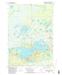
1979 Map of Anchorage C-8 SW
USGS Topo · Published 1997About this map
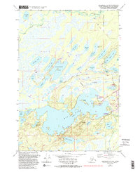
The expansive waters of Big Lake dominate this 1993 revised landscape in the Matanuska-Susitna Borough, where a network of recreational sites and residential pockets follows the irregular shoreline. The map reveals a transition from the structured recreational access at Big Lake North State Recreation Site and Big Lake South State Recreation Site to the more remote stretches of the Little Susitna River in the north. This era reflects the area's growth as a hub for lake-based activity, featuring numerous Boat Docks and a Radio Facility near Colt Lake. Inland, the terrain is defined by a dense cluster of water bodies including Horseshoe Lake, West Beaver Lake, and the uniquely shaped Hourglass Lake. Traces of industrial and transportation infrastructure appear through scattered Gravel Pits and the long Winter Trail corridors that cross the marshy lowlands.
Find a feature on this map
50 named features on this map. Tap any name to fly to it.
Don’t see what you’re looking for? This feature index may not catch every label — zoom into the map to look around manually.
Map Details
Editions of this 1979 Anchorage C-8 SW Map
5 editions found
Other maps of this area

1949 · Tyonek
USGS Topo · 1:250,000

1950 · Anchorage C-8
USGS Topo · 1:63,360

1951 · Anchorage
USGS Topo · 1:250,000

1951 · Tyonek
USGS Topo · 1:250,000

1952 · Anchorage C-8
USGS Topo · 1:63,360

1952 · Tyonek C-1
USGS Topo · 1:63,360

1952 · Anchorage B-8
USGS Topo · 1:63,360

1953 · Anchorage B-8
USGS Topo · 1:63,360

1958 · Tyonek B-1
USGS Topo · 1:63,360

1958 · Tyonek C-1
USGS Topo · 1:63,360